
Context:
- Himachal Pradesh has been hit by intense rainfall, resulting in cloudbursts and landslides that have obstructed numerous roads and caused houses to collapse.
- This monsoon season, the state has experienced a total of 170 cloudburst and landslide events, causing damage to around 9,600 houses.
- Cloudbursts occur mostly over the rugged terrains of the Himalayas, Western Ghats, and northeastern hill states of India.
- The intensity of cloudbursts have increased during the last 10-15 years because of massive urbanisation, increased population and higher temperature.
- Definition: According to the Indian Meteorological Department (IMD), 100mm of rain in an hour is called a cloudburst.
- Scale of occurrence: The cloudbursts usually occur over a small geographical region of about 20 to 30 sq. km.
- Occurence in India: In India, cloudbursts are frequently observed during the monsoon season, particularly over regions like the Himalayas, the Western Ghats, and the northeastern hill states.
- Linkage with Flash floods: Cloudbursts often result in flash floods and have become increasingly common from May-September when the southwest monsoon season prevails in much of the country.
- Role of southwesterly monsoon: It occurs when warm monsoon winds interact with cold winds leading to the formation of massive clouds. During monsoon, the southwesterly monsoon winds carry a lot of moisture inland.
- Orographic lift: As these moist air masses converge over the land and encounter hills, they rise in altitude.
- Formation of cumulonimbus clouds: As the air reaches higher altitudes, it becomes saturated and the moisture condenses, it results in the formation of intense cumulonimbus clouds.
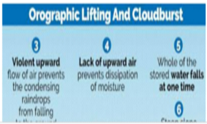
- Violent upward flow of air: In hilly areas, sometimes saturated clouds ready to condense into rain, cannot produce rain, because of the upward movement of the very warm current of air. Instead of falling downwards, the raindrops are carried upwards by the air current.
- Heavy Downpour: After a point, the raindrops become too heavy for the cloud to hold on to, and they drop down together resulting in torrential downpours in the region right below and leads to overflowing of water bodies in a very short duration of time.
- Rugged topography: Mountainous areas offer the terrain for moisture-laden air to rise swiftly along the mountain slopes.
- Warming of oceans: Oceans are warming up fast, as a result of which moisture-rich air reaches the Himalayan region leading to cloudburst. It is likely to occur more with an increase in moisture from the Indian Ocean.
- Increase in frequency: Climate change and rise in greenhouse gas emissions is projected to increase the frequency and intensity of cloudbursts worldwide.
- Clausius Clapeyron relationship: As per this, as the air gets warmer, it can hold more moisture and for a longer time. A 1-degree Celsius rise in temperature may correspond to a 7-10% increase in moisture and rainfall.
- Uneven distribution of rainfall: As the moisture holding capacity of air increases, it results in prolonged dry periods intermittent with short spells of extreme rains. More deeper cumulonimbus clouds form, and the chances of cloudbursts increase.
- Localized: Due to their highly localized and short occurrence, most of the events go unreported, weakening the ability to understand these events in complete perspective.
- Prediction: Most of the reported cloudbursts are in the interior of the Himalayas and hence predicting the location, amplitude and magnitude of such catastrophic events in advance remains a challenge.
- Inability of satellites: Satellites lack the ability to detect cloudbursts because the resolution of their precipitation radars is considerably smaller than the area covered by each cloudburst event.
- Cost of Weather radars: Although they can offer timely updates, their cost is quite high.
- Weather uncertainties: The skillful forecasting of rainfall remains challenging due to the uncertainties in the interaction between the moisture convergence and the hilly terrain, the cloud microphysics, and the heating-cooling mechanisms at different atmospheric levels.
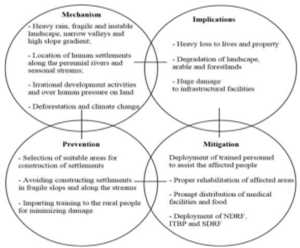
- Environmental Impact: Heavy spells of rain on the fragile steep slopes trigger landslides, debris flows, and flash floods, causing large-scale destruction.
- Cloudbursts in isolated areas in Himachal PPradeshand Uttarakhand have triggered landslides and flash floods that have disrupted rail and road traffic, and resulted in house and wall collapses.
- Economic Impact: It leads to extensive damage to infrastructure and property as well as disruption of livelihoods.
- Recent cloudburst resulted in a tragic loss of at least 48 lives as well as damaged the Unesco world heritage Shimla-Kalka railway line.
- Since the onset of monsoon on June 24, about 652 houses have been completely damaged in Himachal Pradesh, while 6,686 were partially damaged besides 236 shops and 2,037 cow sheds, according to the data of the state emergency response centre.
- Agricultural Losses: Excessive rainfall in a short time can flood fields, destroy crops, and result in significant economic losses for farmers.
- A cloudburst in Rampur subdivision of Shimla district damaged a school, two houses and agricultural land.
- Expansion of doppler radar footprints: To prevent damage to life and property caused by extreme rainfall events, the India Meteorological Department (IMD) has planned massive expansion of its doppler radar footprints to improve forecast of cloudbursts.
- Automatic weather stations: IMD has come up with a plan to set up automatic weather stations in every block and automatic rain gauge in each panchayat of the country.
- Augmented weather observation systems: States like Odisha are augmenting their weather observation systems. The plan is to have an integrated observation system which IMD will monitor and provide the forecasts.
- Multiple doppler weather radar: It can be used to monitor moving cloud droplets and help to provide nowcasts (forecasts for the next 3 hours).
- This can be a quick measure for providing warnings, but radars are an expensive affair, and installing them across the country may not be practically feasible.
- Mapping the cloudburst-prone regions: A long-term measure would be mapping the cloudburst-prone regions using automatic rain gauges.
- Designation of site as hazardous: If Cloudburst-prone regions are co-located with landslide-prone regions, these locations can be designated as hazardous.
- The risk at these locations would be huge, and people should be moved, and construction and mining in nearby regions should be restricted as it can aggravate the landslides and flash flood impacts.
- Preventive Policies: Urgent action and policies are needed to protect lives and property from extreme events that will amplify as the global temperature change doubles.
- Implementing Cloudburst management techniques: It implements a combination of methods that absorb, store, and transfer stormwater to minimize flooding from cloudburst events.
- Using grey infrastructure, like sewer pipes and underground storage tanks, and green Infrastructure, like trees and rain Gardens, cloudburst management can minimize damage to property and infrastructure by reducing strain on the Sewer System.