
Context
June-August 2023 marks the sapphire jubilee (65th anniversary) of the exploration of the Siachen glacier held for the first time in 1958. During the geological surevy, a number was assigned to Siachen glacier by the Geological Survey of India (GSI), i.e. ‘5Q 131 05 084’. What is a Geological survey?- Geological survey is a systematic examination of an area to determine the character, relations, distribution, and origin or mode of formation of its rock masses and mineral resources, usually capitalized G&S, a governmental bureau charged with making geological surveys.
Relevance of “1958”
|
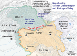
- The Siachen Glacier is located in the Eastern Karakoram Range in the Himalayas, just northeast of Point NJ9842 where the Line of Control between India and Pakistan ends.
- The entire Siachen Glacier, with all major passes, is currently under the administration of India since 1984 (Operation Meghdoot).
- India currently occupies dominating positions on the Saltoro ridge with Pakistani posts located 3,000 feet below.
 Geography of the Location:
- It is situated to the north of Nubra Valley, which is located in the east of Leh.
- The Siachen Glacier lies immediately south of the great drainage divide that separates the Eurasian Plate from the Indian subcontinent in the extensively glaciated portion of the Karakoram sometimes called the “Third Pole“.
- It is the Second-Longest glacier in the World’s Non-Polar areas.
- The Siachen Glacier is part of Ladakh which has now been converted into a Union Territory.
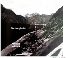
- The Siachen Glacier is the world’s highest battlefield.
 Significance of Siachen glacier:
- The status of glaciers in the Karakoram has a direct impact on some of the key components of the:
- global water cycle
- global mean sea-level rise
- freshwater availability
- Besides, continuous monitoring of glaciers is crucial for identifying the regional impacts of changing climate particularly where long-term climatic measurements are rare. There are also the risks of Glacial Lake Outburst Floods and droughts.
Geological Survey of India (GSI):
|